Malton, North Yorkshire — Coordinates: 54°08′20″N 0°47′31″W / 54.139°N 0.792°W / 54.139; 0.792 … Wikipedia
trigonometry — trigonometric /trig euh neuh me trik/, trigonometrical, adj. trigonometrically, adv. /trig euh nom i tree/, n. the branch of mathematics that deals with the relations between the sides and angles of plane or spherical triangles, and the… … Universalium
U.S. Army Combat Arms Regimental System — The Combat Arms Regimental System (CARS), was the method of assigning unit designations to units of the five combat arms (Infantry, Field Artillery, Armor, Cavalry, and Air Defense Artillery) of the United States Army from 1957 to 1981. CARS was… … Wikipedia
Street or road name — For other uses, see Street name (disambiguation). Abbey Road in London … Wikipedia
History of algebra — Elementary algebra is the branch of mathematics that deals with solving for the operands of arithmetic equations. Modern or abstract algebra has its origins as an abstraction of elementary algebra. Historians know that the earliest mathematical… … Wikipedia
Richmond District, San Francisco — Richmond District Neighborhood of San Francisco Geary Boulevard, looking eastward from 36th Avenue in the Outer Richmond … Wikipedia
Street name — A street name or odonym is an identifying name given to a street. The street name usually forms part of the address (though addresses in some parts of the world, notably most of Japan, make no reference to street names). Buildings are often given … Wikipedia
Georef — (World Geographic Reference System) is a grid based method of specifying locations on the surface of the Earth. Georef is essentially based on the geographic system of latitude and longitude, but using a simpler and more flexible notation. Georef … Wikipedia
Chatham Grammar School for Boys — Motto Turning potential into reality Established 1817 Type Selective grammar school; Comprehensive Sixth Form … Wikipedia
Washington & Old Dominion Railroad Regional Park — The Washington Old Dominion Railroad Regional Park is a popular and unusually shaped regional park in Northern Virginia. The park s primary feature is the Washington Old Dominion Railroad Trail (abbreviated as W OD Trail), an asphalt surfaced… … Wikipedia
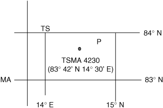 A point that lies at 83 degrees 42 minutes North and 14 degrees 30 minutes East may be expressed in lettered coordinates as TSMA 4230.